
Drone Mapping and 3D Modeling Services in Charleston, WV
UA-Visions provides drone mapping and 3D modeling services for construction sites, real estate development, land documentation, infrastructure, and telecom assets across Charleston, WV and surrounding areas. We operate an RTK (Real-Time Kinematic) drone with a physical ground base station, which delivers centimeter-level positioning accuracy that standard consumer drone GPS cannot match.
Deliverables include orthomosaic maps, digital elevation models, 3D terrain models, volumetric measurements, and site overview imagery. Files are compatible with Pix4D, DroneDeploy, and standard CAD and GIS formats. Every project is scoped before flight so the imagery, accuracy level, and deliverables match what your team actually needs.
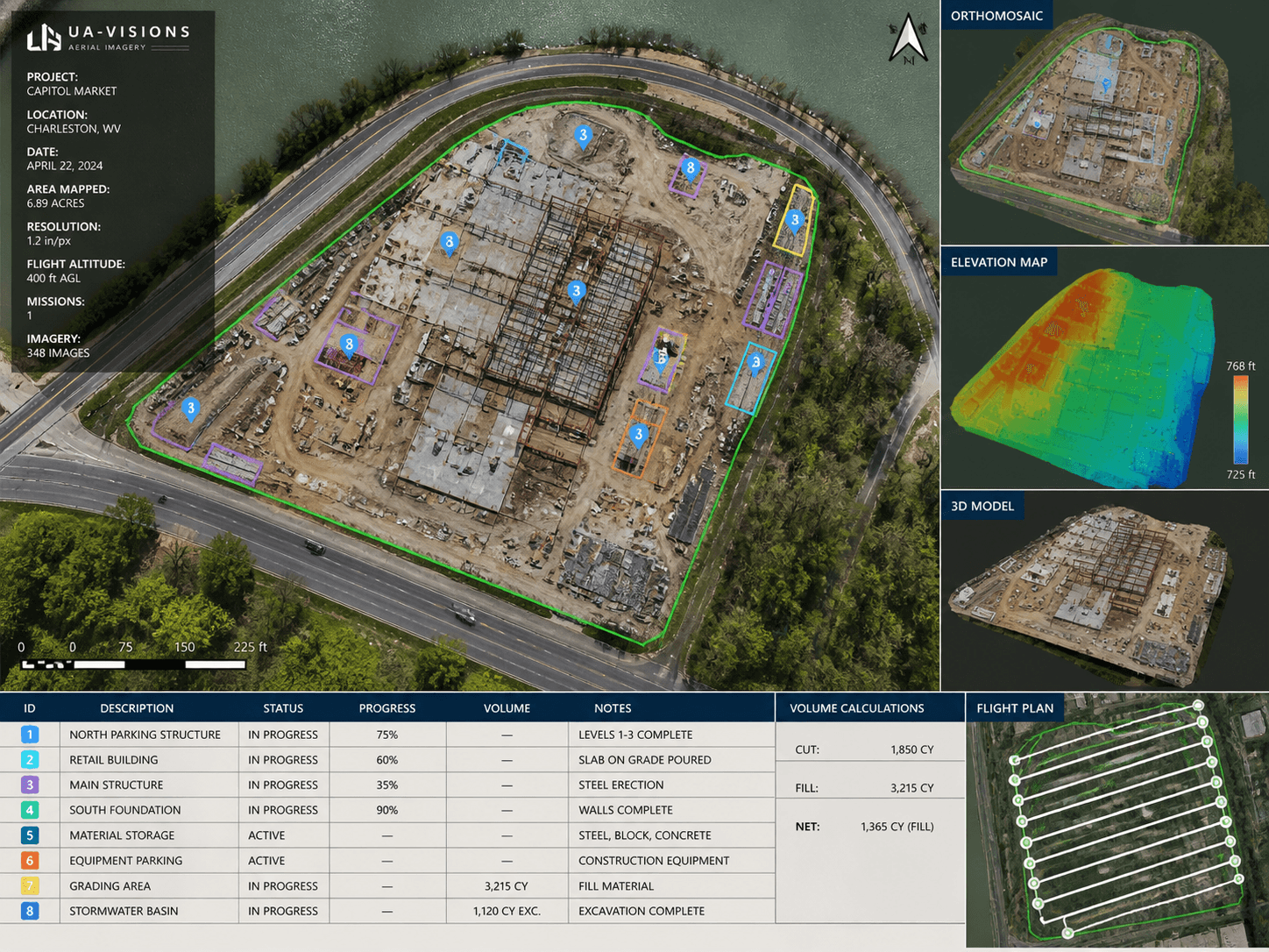
Mapping Support for Sites that Need More Than Standard Aerial Photos
Standard drone photos are useful, but some projects need a more organized, measurable view of the site. Drone mapping documents site layout, access points, terrain features, building placement, stockpile and staging areas, roof geometry, tower components, and project changes over time — with the RTK base station providing the positional accuracy that makes those measurements reliable enough for engineering and construction decision-making.
UA-Visions is based near Charleston, WV and supports mapping projects across Kanawha County, Putnam County, and nearby communities including South Charleston, Cross Lanes, Nitro, St. Albans, Teays Valley, Hurricane, Winfield, and Dunbar.
Mapping scope is confirmed before the flight. For projects requiring legal boundary surveys, stamped engineering documents, or certified measurements, those products must be produced or validated by the appropriate licensed professional. UA-Visions provides aerial data capture, RTK-supported mapping outputs, and visual documentation that feeds into those workflows.
Common Mapping Uses
Construction: progress documentation, staging areas, site access, owner updates, and repeatable visual records.
Real estate and land: property context, development planning, marketing visuals, access routes, and terrain awareness.
Infrastructure: exterior asset documentation, route context, condition imagery, and planning support.
Telecom and structures: tower modeling inputs, component documentation, height context, and maintenance planning visuals.
Drone Mapping and 3D Modeling Services
Each project is scoped before flight so the imagery, flight pattern, and deliverables match the intended use.

Orthomosaic and site mapping
Overlapping aerial imagery processed into orthomosaic maps produces consistent, georeferenced site views that go well beyond a single aerial photo. RTK positioning improves the accuracy of these outputs so measurements taken from the map — distances, areas, stockpile volumes — reflect real-world conditions with precision useful for construction planning, progress documentation, and access review.

3D model inputs and reconstruction
Drone imagery supports photogrammetry-based three-dimensional models for structures, roofs, towers, land features, and project sites. Models give teams a detailed spatial reference for reviewing placement, elevation changes, component access, and site conditions before committing to field work or equipment mobilization.
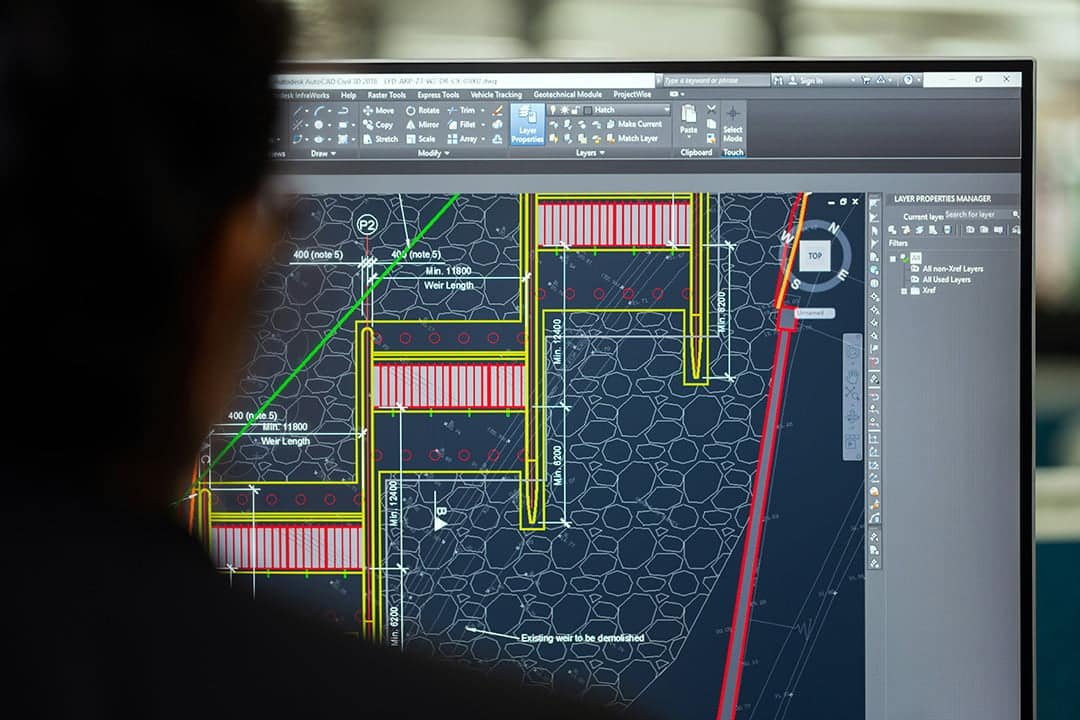
Practical Deliverables for Planning, Documentation, and Review
Deliverables are confirmed before the flight. Depending on project scope, outputs include high-resolution aerial photos, orthomosaic maps, digital elevation models, overview imagery, video clips, processed map views, 3D model inputs, annotated visuals, and folders organized by area, asset, date, or project phase. File formats are matched to the platforms your team uses.
For construction and infrastructure projects, these files support owner reporting, stakeholder briefings, documentation packages, pre-work planning, access coordination, and date-over-date progress comparison. For real estate and land development, mapping imagery shows site context, terrain, structure placement, road access, and surrounding development with the accuracy needed for early-stage planning decisions.
Before scheduling, we confirm what the files need to support so the flight is planned around useful results instead of collecting imagery without a clear purpose.
How the Mapping Process Works
1. Scope the site
We confirm the location, project purpose, access limits, deliverables, flight area, timing, and any safety concerns.
2. Plan the flight
We review airspace, weather, site hazards, launch area, image overlap requirements, and all applicable FAA Part 107 requirements before every commercial flight.
3. Capture imagery
We collect the needed aerial photos, mapping images, video, or model inputs using a flight plan matched to the project.
4. Deliver files
You receive organized files that can be reviewed internally, shared with contractors, or used to support planning and documentation.
RTK Accuracy, Clear Scope, and FAA-Compliant Operations
UA-Visions operates an RTK drone with a physical ground base station, which significantly improves positional accuracy compared to standard drone GPS. For most mapping projects, RTK outputs deliver centimeter-level horizontal accuracy and sub-5cm vertical accuracy under good conditions. Actual accuracy depends on flight altitude, image overlap, lighting, terrain complexity, ground control configuration, and processing method. For projects requiring legal survey products or engineering certifications, those must be produced or validated by a licensed professional — we provide the aerial data capture that feeds those workflows.
UA-Visions holds FAA Part 107 certification and operates all commercial drone work under applicable FAA requirements, including airspace authorization when required. Review FAA commercial drone operator information.
If your project requires legal boundary determination, stamped engineering documents, or certified survey products, we coordinate aerial data capture while you engage the licensed professionals required for those deliverables. The combination of RTK aerial data and licensed survey or engineering review gives you both speed and legal defensibility.
RTK accuracy for mapping and measurement
UA-Visions uses a D-RTK 2 Mobile Ground Station paired with an RTK-enabled drone. The base station provides real-time positioning corrections on site, combining GPS, GLONASS, BeiDou, and Galileo signals for centimeter-level horizontal and vertical accuracy. This is the same precision standard used in traditional land surveying, captured from the air. For construction earthwork calculations, cut-and-fill analysis, volumetric measurements, and as-built documentation, this level of accuracy is what separates useful data from aerial photography.

Helpful information to send
- Project address or coordinates
- Approximate area to be mapped
- Purpose of the mapping work
- Preferred deliverables and file formats
- Deadline or recurring flight schedule
- Known site access limits or hazards
- Any contractor, owner, or engineer requirements
Drone Mapping and 3D Modeling Frequently Asked Questions
What is drone mapping?
Drone mapping uses overlapping aerial images, processed through photogrammetry software, to produce orthomosaic maps, digital elevation models, and 3D terrain models of a site. When paired with RTK positioning and a ground base station, the resulting data includes centimeter-level accuracy suitable for construction measurement, earthwork analysis, and planning applications that standard aerial photos cannot support.
What is 3D modeling with a drone?
Drone-based 3D modeling uses aerial images captured from multiple angles and altitudes to build photogrammetry-based models of structures, terrain, and site features. The result is a spatially accurate 3D representation that teams can use to review tower components, roof geometry, terrain contours, building context, and site conditions without repeated field visits.
Is drone mapping the same as a land survey?
No. RTK drone mapping produces highly accurate spatial data, but it does not replace a licensed land survey when legal boundary determination, stamped survey documents, or certified measurements are required. UA-Visions provides the aerial data capture; a licensed surveyor or engineer provides the legal certification when your project requires it. Many clients use both: our RTK data for planning and documentation, and a licensed professional for the legal record.
What areas do you serve?
UA-Visions supports drone mapping and 3D modeling Charleston WV projects and serves nearby areas including South Charleston, Cross Lanes, Nitro, St. Albans, Teays Valley, Hurricane, Winfield, Dunbar, Kanawha County, Putnam County, and other West Virginia locations by request.
What deliverables can I request?
Deliverables include high-resolution aerial photos, orthomosaic maps, digital elevation models, processed map imagery, video clips, 3D model inputs, annotated visuals, and organized project folders. File formats are matched to the platforms you use — Pix4D, DroneDeploy, AutoCAD, GIS software, or standard image formats. The complete deliverable list is confirmed before scheduling.
How do I request a quote?
Send the project address or coordinates, mapping purpose, approximate site area, accuracy requirements, preferred deliverables, and your timeline. If you have existing site plans, boundary maps, or prior aerial imagery, include those — they help us plan the flight for the right coverage and overlap pattern.
Request drone mapping support for your site
Contact UA-Visions to discuss your mapping project. We confirm location, accuracy requirements, deliverables, and flight plan before scheduling. Based in Charleston, WV and available throughout West Virginia.
Request a drone mapping quote | Drone construction monitoring | Aerial drone inspections | Drone services
Get in touch